

As the United Kingdom experiences one of its warmest autumns in recorded meteorological history, some forecasters are warning that the winter ahead will be exceptionally harsh. Heavy snow, polar gales, record low temperatures and even blizzards are predicted to strike the entire country as December approaches. The arrival of the super cold weather is expected within weeks, reports the Sunday Express.
Meteorologists have warned that the unusually mild autumn, which saw temperatures of 23 degrees Celsius in the London area over Hallowe’en, will make way for a tough winter, with “extreme and potentially devastating weather” causing considerable disruption to daily life, the Sunday Express claims. While the country has been basking in almost late summer type weather thanks to warm air circulating in from Portugal, experts studying air flows in the upper atmosphere have produced readings using the October Pattern Index (OPI ) have predicted the appearance of an ‘Arctic Oscillation‘ where bitterly cold air seeps in from the Arctic region, bringing in weather typical of that part of the world. The jet stream is substantially weakened. That means cold air which normally is held back over northern Canada, Greenland and other Arctic areas will be free to flow southwards, with the British Isles firmly in its sight. A blast of freezing air will bring with it biting cold winds and above average rates of snow and meteorologists claim that the extreme wintry weather will make its appearance felt around mid-November, according to their OPI predictions. Transport chaos is expected, as airports, motorways and train stations not used to harsh winters struggle to manage the excess amounts of fallen snow and high winds.
The OPI was devised by Italian scientists Riccardo Valente and Professor Judah Cohen. They have claimed that the readings on the index taken for this year are disturbingly similar to those calculated during the severe winter of 2009-2010. Ice-cold winds and ankle-deep snow in London at that time caused entire Tube lines to be shut down and grit supplies to run out amid the wintry chaos. The winter of 2009-10 was said to have been the coldest in thirty-one years.
James Madden, forecaster for Exacta Weather said: “We are reaching a stage where the final OPI value is currently at -2.43.
“Anything below -1.5 correlates highly with a blocked winter pattern of cold and snow for the UK.
“It appears to correlate well with a scenario similar to the winter of 2009/10 at the very least.
“In addition to this the Siberian snow cover is also well ahead of schedule and is another strong signal for a harsh winter based on previous studies for a negative Arctic Oscillation for the December to March period.
“The worst case and more plausible scenario could bring something on a similar par to the winter of 2009/10, the coldest in 31 years, or an event close to 2010/11 which experienced the coldest December in 100 years.”
Another weather expert, Jim Dale, a forecaster with the British Weather Services, told the Sunday Express that experiencing such a mild autumn is a given precursor to an particularly cold winter, as the climate follows a ‘balancing pattern’ where if an autumn is warm, the weather system makes up for the lack of autumnal cold by concentrating it during the winter months in order to achieve temperature balance.
He said: “We could see a sharp difference as the winter unfolds, this mild weather could bring a false sense of security.
“There is always another side to the coin and in the long run on the balance of probability we could see a very different picture.
“I am not sure about a record winter, but certainly things have a way of balancing out.”
James Madden warned the public to brace themselves for a “shock to the system” with a “significant” snow event possible in weeks, possibly affecting most of the country, including warmer southern areas.
He said: “As we progress throughout November, it will begin to turn gradually cooler, in particular, within the second half of the month as blocking becomes a more prominent feature and the jet stream diverts further south.
“This will be due to expanding cold from the Arctic region, and this will also allow for the development of some much colder intrusions of air and snow for the UK.
“Some of the snow events are likely to be quite significant with blizzards across higher ground, and a number of potentially notable snow events are also possible across some lower levels within this period, in particular, in some exposed coastal areas to the north and west of the country.
“We are also likely to see the development of some widespread frosts and rather extensive fog patches across the country within this period, and this will come as quite a shock to what we have experienced throughout this autumn to date.
“However, some spikes of milder conditions may also develop within this period, in particular, in some parts to the south of the country, and these will be accompanied by some rather windy and quite stormy conditions at times.”
Even as this passing October saw the country experience above-average conditions which saw beach resorts smash profit records for the half-term break, several local authorities have already begun winter preparations, including organising fleets of gritters and filling grit banks. They are keep a close watch on temperatures as November 2014 progresses, which may give only two weeks to get ready for the deluge of snow and icy winds that the weather watchers are predicting.
In Aberdeen, Scotland, a council spokesman said: “We have started monitoring temperatures and if there is a snap frost in a week’s time we are ready to respond “.
A spokeswoman for Orkney Islands Council said the authority is gearing up for the winter season by preparing gritters and other equipment.
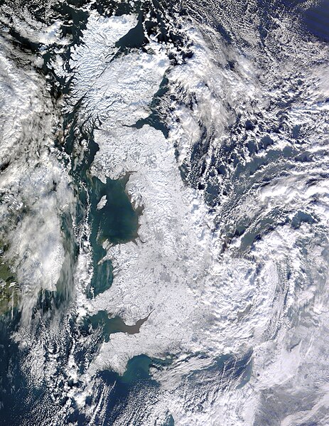
The super winter of 2009 and 2010, which the media dubbed the ‘Big Freeze’ brought so much snow to the British Isles that satellite pictures taken from outer space at the time showed the entire country covered in white. Temperatures of −17.6 °C (0.3 °F) were reported in the Manchester urban area in January 2010. In the same month, a far lower reading was made at the remote village of Altnaharra, Scotland where thermometers showed a finger-numbing −22.3 °C (−8.1 °F). The tough winter saw widespread transport disruption, school closures, power failures, the postponement of sporting events and 25 deaths. Thousands of injuries were seen by doctors and medical workers from road accidents and people slipping on black ice. The Met Office issued severe weather warnings for nearly all parts of the United Kingdom. At the time, the RSA Insurance Group estimated that the cold weather was costing £690 million per day, due to people unable to get to work or deliver goods, among other factors. Extra potholes and burst water pipes on roads are also believed to have cost £61 million and £20 million in repairs. Use of natural gas increased by one-third as people battled to keep the extreme cold from their homes.
SOURCES:
Vipul Bhundia via Inga Nelson, Facebook/Facebook Inc. https://www.facebook.com/
“Britain to face ARCTIC WINTER as mild autumn triggers polar gales and heavy snow” – Nathan Rao, Sunday Express/Northern and Shell Media Publications (28 October 2014) http://www.express.co.uk/news/nature/528643/Winter-2014-weather-warning-snow-arctic-freezing-temperatures-forecast
“Winter of 2009–10 in Great Britain and Ireland” – Wikipedia/ Wikimedia Foundation, Inc. http://en.wikipedia.org/wiki/Winter_of_2009%E2%80%9310_in_Great_Britain_and_Ireland
IMAGE CREDITS:
“File:Great Britain Snowy.jpg” – Jeff Schmaltz/MODIS/NASA, Wikipedia/Wikimedia Foundation, Inc. (9 January 2010) http://en.wikipedia.org/wiki/File:Great_Britain_Snowy.jpg
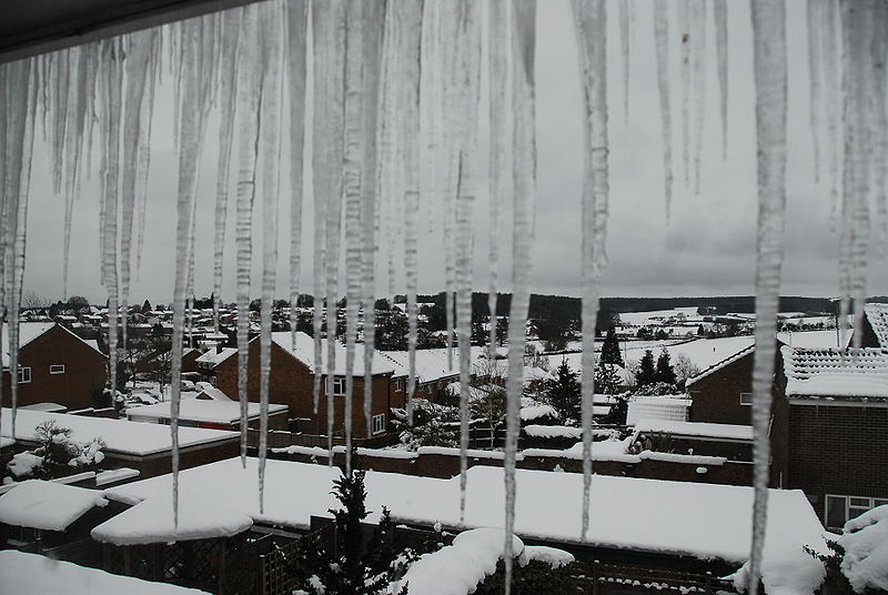
“File:Alton 10 Jan.JPG” – Ericoides, Wikipedia/Wikimedia Foundation, Inc.(10 January 2010) http://en.wikipedia.org/wiki/File:Alton_10_Jan.JPG


You know…they’re saying the same thing for Canada too…sounds like this winter is going to be a tough one. Rats.
LikeLiked by 1 person
Que sera, sera. Let’s see what happens if it snows it snows. What’s the point in worrying about something we can not do anything about.
LikeLike
Yeah you’re right, we cant stop it, might as well enjoy it 🙂
LikeLike
I’ll better get the winter tyres on…
LikeLiked by 1 person
Oh no… Still enjoying the warm weather here… just rainy
LikeLike
So far here, its now mid-November and no crazy snow flurries yet…just dull grey skies and rain. Today I nipped out to get a bottle of milk and it was quite depressing. I couldn’t wait to get back home.
LikeLiked by 1 person
Wish we could have had some snow the other day, where I am, the temperature reached 45.3C – that’s 113.54F, and it isn’t even summer yet 😮
LikeLike
45.3C…..that’s insane, must have been so uncomfortable!
LikeLike
Jjust a bit 😀
LikeLiked by 1 person
I’m glad that we live in the southern part of the U.S. Thanks for following Humorous Interludes. I am humbled and delighted.
LikeLike
My pleasure Ron, and likewise for following me back at the Half-Eaten Mind. I would love to visit the southern US one day 🙂
Vijay
LikeLiked by 1 person